Global Uranium Wyoming Assets
WYOMING URANIUM
Wyoming boasts a rich history of uranium production and is home to active uranium mining and historic mineral resources, with Global Uranium holding 5,040 acres of land.
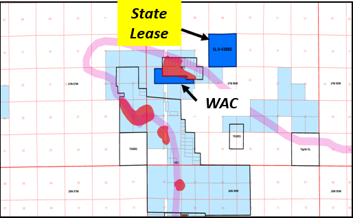
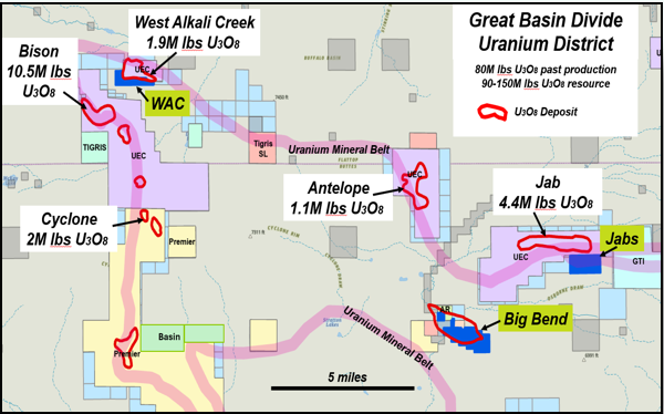
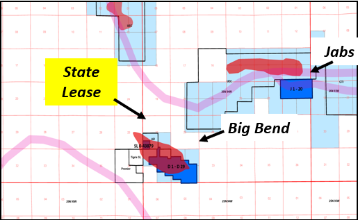
The Great Divide Basin District: 80M lbs. past production, 90-150M lbs resource
- Hosts Ur-Energy Inc’s (URE) producing Lost Creek ISR uranium processing plant and the 18M lbs of U₃O₈ Lost Creek deposit. Other known deposits in the vicinity include URE’s Lost Soldier and Uranium Energy Corp’s (UEC) Jab and Antelope deposits. These deposits total 95M lbs of U₃O₈
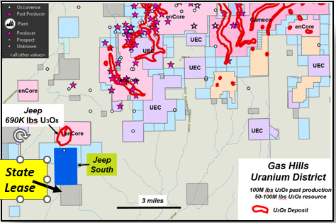
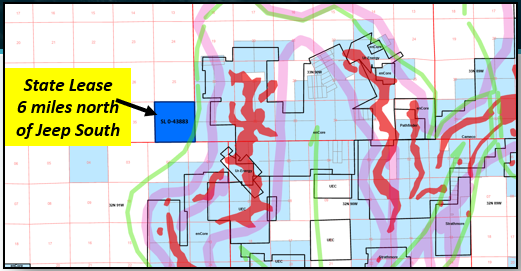
Gas Hills Uranium District: 100M lbs. past production, 50-100M lbs resource
- The #1 uranium mining area in Wyoming. Past production in the Gas Hills exceeded 100M lbs of U₃O₈. Historical and recent reports suggest 50-100M lbs of U₃O₈ resources remain in the Gas Hills, with significant discovery potential in the less explored areas to the south, in the Beaver Rim area.
Copper Mountain Uranium District: 500,000 lbs. past production, 15.7 M to 30.1M lbs. potential
- Hosts several known uranium deposits and historic uranium mines, including the Arrowhead Mine which produced 500,000 lbs of U₃O₈. Copper Mountain saw extensive drilling and development by Union Pacific, which developed a mine plan and built a leach pad for one of the deposits at Copper Mountain.
Sources: https://www.wsgs.wyo.gov/products/wsgs-2019-pic-47.pdf
https://myriaduranium.com/wp-content/uploads/2023/09/copper-mountain-43-101-technical-report.pdf
Airline #2 Project Overview
-
The Airline Project includes 8 mineral claims totaling 166 acres, plus a 640-acre State lease, located within Wyoming’s Wind River Basin. -
The Wind River Basin is a historic uranium-producing area, with 500,000 lbs of U₃O₈ reportedly mined between 1955 and 1970, demonstrating the district’s proven fertility. -
Geological records point to multiple uranium showings and untested zones within and near the project area, consistent with the broader district’s mineralization style. -
The project is easily accessible year-round by paved highways and local roads from Riverton and Shoshoni, Wyoming.

Airline #2 Project Geology
-
Past exploration focused on intrusive-related uranium around granite bodies and associated alteration zones. -
Uranium also occurs in sedimentary settings, controlled by permeable layers and natural reductant traps. -
The younger Tertiary cover offers potential for roll-front uranium systems, similar to producing deposits elsewhere in Wyoming. -
Deeper potential exists for thrust-related and unconformity-style uranium, where structural repetition and basement contacts create favorable traps. -
The varied geological setting positions the Airline property as a multi-style uranium project with both near-surface and deeper, high-value targets.

Airline #2 Project Recent Work
-
Global Uranium has performed two phases of exploration since 2024. -
Phase 1: Completed a desktop compilation of publicly available data, including environmental, permitting, geologic, geophysical, and exploration history information, to establish a baseline GIS database and exploration framework. -
Phase 2: Conducted a reconnaissance radiometric survey using a handheld scintillometer across a 100 m x 100 m grid, successfully identifying anomalies requiring higher-resolution follow-up.

Future Work
Phase 3 | Q3-2025
-
Expand the land package to secure additional prospective ground and cover extensions of favorable geology.
Phase 4 | Q4-2025
-
Carry out detailed mapping to confirm stratigraphy and faults, collect surface samples, and complete higher-resolution radiometric surveys over anomalies.
Phase 5 | Q1-2026
-
Compile historic and new datasets into an integrated model to rank anomalies and refine drill targets.
Phase 6 | Q2-2026
-
Advance permitting for the highest-priority drill areas, including access plans and environmental considerations.
Phase 7 | Q3-2026
-
Drill test the strongest anomalies and structural corridors to validate models and confirm mineralization.
WAC Project
-
The WAC Project has 11 claims covering 220 acres located in the Great Basin Divide Uranium District. -
The WAC Project is Adjacent to the 1.8M lbs. West Alkali Creek deposit and one mile northeast of 10.5M lbs. Bison Basin deposit, both deposits are owned by Uranium Energy. -
Global Uranium also has one State Lease covering 640 acres in the Great Basin Divide Uranium District. -
Access to the WAC project is from Lander drive 39 miles east on Highway 287 to Sweetwater Station, drive south 15 miles on Bison Basin Road then 8 miles east on Riverview Road Cutoff. -
Bison Basin is a small depression at the southeast end of the Wind River Range. -
The WAC Project is separated from the Great Divide Basin by a basement high that extends eastward from the Wind River Range into central Wyoming. Precambrian crystalline rocks form the basement. -
The WAC Project overlain by a thick sequence of sediments ranging in age from Carboniferous, Cretaceous to Tertiary. Two major structural elements, the Wind River thrust, a steeply dipping regional fault, and the Bison Basin fault, a smaller thrust fault, occur at the south and north sides, respectively, of the basin. -
At the adjacent West Alkali Creek deposit uranium is hosted in Eocene arkosic sediments, primarily sandstones of the Wasatch Formation. Deposits are located along the flanks and bottom of the Cyclone Rim syncline and are controlled by boundary faults at the margins of the syncline.


JABS Project
-
The JABS Project has 20 claims covering 400 acres located in the Great Basin Divide Uranium District. -
The JABS Project is adjacent to the 4.4M lbs. Jab deposit and 5 miles east of the 1.1 M lbs. Antelope deposit, both owned by Uranium Energy. -
Seven miles southeast is the 20M lbs. Lost Creek ISR project owned by UR-Energy (2.7M lbs. past production). -
Access to the JABS Project is from Lander drive 39 miles east on Highway 287 to Sweetwater Station, drive south 29 miles on Bison Basin Road then 6 miles west on Bairoil Road. -
The Eocene Battle Springs Formation is the host of the uranium deposits at the Antelope/JAB project area. -
It is approximately 6500′ thick and is comprised of alluvial fan sediments primarily being fine to coarse grained arkosic sandstones, shales, siltstones and some conglomeratic units. -
The source of the sediments is believed to have been the Granite Mountains to the north. The Battle Springs Formation is gradational and interfingers with the Wasatch Formation in the western Great Divide Basin southwest of the JAB area. -
The Wasatch Formation consists of lacustrine and paludal sediments of shales, siltstones, and sandstones. The Battle Springs Formation dips at a low angle 2-5 degrees toward the south in both areas.


Big Bend Project
-
The Big Bend Project has 29 claims covering 580 acres located in the Great Basin Divide Uranium District. -
Global Uranium also controls one State lease that covers an additional 41 acres. -
Prospect with dozer-cut exposures of uranium on 5,000 feet of strike length and 1,500 feet in width. -
The Big Bend Project shows indications of minor past production. -
Access to the Big Bend Project is from Lander drive 39 miles east on Highway 287 to Sweetwater Station, drive south 29 miles on Bison Basin Road then 6 miles west on Bairoil Road. -
The deposit is made up of several thin, irregular tabular mineralized bodies in beds of platy shale of the Green River formation at their contact with beds of sandstone of Wasatch type, or in gray-green silty claystone of Wasatch type. -
These beds have been folded, faulted, eroded, and covered by successive terrace deposits of Pleistocene to Recent gravel, silt, alluvium, and colluvium.


Jeep South Project
-
The Jeep South Project has 54 claims covering 1,080 acres located in Wyoming’s number one uranium mining area, the Gas Hills Uranium District, also including two state leases that covers 1280 acres. -
The Jeep South Project northern boundary is 900 feet south of the 0.46 M lbs. Jeep uranium deposit owned by enCore Energy Corp. (TSX.V:EU). -
The Jeep deposit is open to the south, trending on to the Jeep South Project. -
Access to the Jeep South Project is from Lander drive 58 miles east on Highway 287 to Jefferey City, then north on Fremont County Road #5 for 15 miles. -
The Jeep area drill data consists of 40 drill holes (2007-2013) and 296 drill holes from Pre 2007 drilling. A single mineralized horizon is present in the area occurring at an approximate depth of 270 feet.*
Source: *https://www.wsgs.wyo.gov/products/wsgs-2019-pic-47.pdf


